This is a quick diversion you can find just outside of Gangnam subway station. It's like Samsung decided they wanted to make their own permanent version of CES.
They have several stations set up, like these cycling and baseball games.
You'll find this animated LED display upstairs.
Here's a closer look at the LED display from behind.
I didn't go to CES this year. I believe this is the same Ultra HD TV they brought to Vegas in January. The picture quality is incredible.
On my way out, I saw this girl recording some sort of video segment. I'm not sure if she's famous or not, so I snapped her photo just in case.
Sunday, June 23, 2013
Friday, June 21, 2013
The MDL, the DMZ, and the JSA
One of the highlights of our Korean sojourn was definitely the DMZ tour that we took through Koridoor. Honestly, I mostly wanted to see the JSA because of the Korean film of the same name. But the tour turned out to be so much more educational and entertaining. If you visit Korea, I highly recommend Koridoor's DMZ tour.
For those who need a primer:
Our first stop was the DMZ museum, right by the so-called Third Infiltration Tunnel. (It's the third tunnel that was discovered).
The museum has some useful models of the DMZ and JSA area. This shows the site of the infamous axe murder incident. Basically, two US Army soldiers were trying to cut down a tree to improve visibility when they were attacked and killed by KPA soldiers. We didn't get out of the bus when we drove through this area, so this photo works better than anything I got of the real place. There's also a funny story about Bill Clinton and the Bridge of No Return. I'll save it for the end of the post.
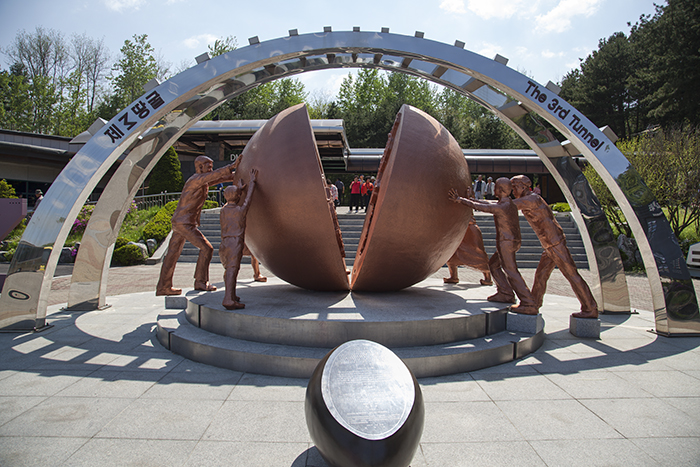
Everywhere you go in the DMZ area, there is this overall theme of hope. This is clearly illustrated in the sculpture below. The people of the north and south are seen trying to reunify their country.
Next on our itinerary was a walk down the Third Infiltration Tunnel. Unfortunately, no photos are allowed. (Don't tell anyone about this one). So I present to you Pocari Sweat. It's a Korean electrolyte drink that I had seen around but never wanted to try—the word "sweat" doesn't exactly sound appealing. In reality, the drink is delicious and especially refreshing after the steep hike back up from the tunnel. Think of it like hiking down the Grand Canyon. It's easy enough going down (and it's very cool underground), but then you have to walk back up.
Our next stop was Dora Observatory. Here's another example of the unification thing. You never know. It could happen.
Dora Observatory has a great view into North Korea and their obnoxiously tall flag. At one point, South Korea built a 100m tall flagpole. In response, North Korea one upped them by building the 160m one you see here. At the time, it was the tallest in the world.
The only thing about Dora Observatory is that they don't allow picture taking past this "photo line." They are very strict about it too. That's why I was so far back when I took the photo above.
Just below Dora Observatory is Dorasan Station (도라산역). It's the northern most station in South Korea. But don't call it the last station.
Here's that hope theme again. Dorasan Station was built entirely from donation money. It's meant to be a gateway of sorts. Once the two sides are reunified, trains will start flowing through Dorasan again.
Only 205 km to Pyeongyang!
Stop! Currently, trains terminate at Dorasan. Obviously, the hope is that they one day continue farther north.
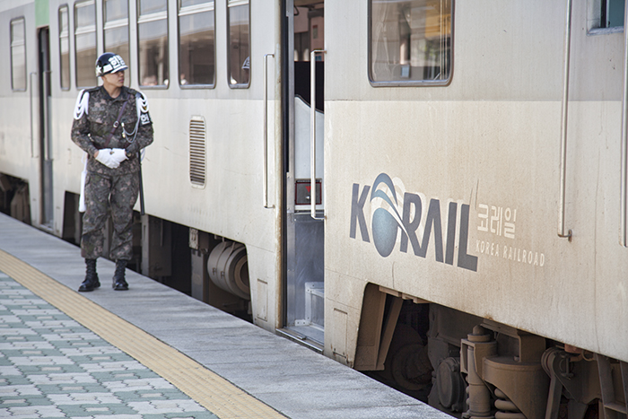
From what I understand, the only people on these trains are the commuting workers in the area.
Enough of Dorasan. It's finally time to see the JSA! In order to do so, we had to get off the Koridoor bus at Camp Bonifas, sit through a briefing from some US soldiers, and then get on a US Army bus. For the hour we were in the JSA, we were in the hands of the United States military.
And here is the JSA. I hope it wasn't too anticlimactic for you. Trust me, it was the highlight of my day.
On this particular day, the North Koreans were doing some sort of construction. As a result, they had way more KPA soldiers than usual. And as a result of that, we weren't able to go inside the UNCMAC building. Normally, you can enter the building and have one foot on either side of the MDL.
I'm OK with not stepping foot in North Korea. I was happy to see more soldiers to photograph. That's the whole reason I wanted to visit the JSA. Again, it's all because of that movie. The ROK is very strict about how you are allowed to take photos. In a nutshell, we were only allowed to photograph in the direction of North Korea. Strange rule, but that was perfectly fine with me.
The ROK soldiers in the helmets are standing in a modified Taekwondo stance. They face and watch the enemy at all times. In comparison, the KPA soldiers face each other. People joke that they do so in case the other soldier tries to defect.
After seeing the famous blue buildings, we got a closer look at that huge North Korean flagpole. From this vantage point, it was easy to only take photos in the direction of North Korea. This is because North Korea was in front of us, as well as to our left and right. We were surrounded.
We survived! Our last stop was at this restaurant where we had Bibimbap (비빔밥) cafeteria style. It was actually pretty good (and not at all blurry in real life).
On the bus back to Seoul, they ended up playing the JSA movie on the bus—a fitting end to our tour.
As for that Bill Clinton story I mentioned earlier, it goes something like this (as told by one of the US Army Specialists on our tour).
For those who need a primer:
- The MDL is the military demarcation line that separates the two Koreas. Technically, the two sides are still at war, but they temporarily agreed to stop fighting in 1953 when the armistice was signed.
- The DMZ or demilitarized zone is the 2km buffer on each side of the MDL. In other words, the DMZ is about 4km wide. There aren't supposed to be any military installations within the DMZ, hence the name demilitarized zone.
- The JSA or Joint Security Area is the one place along the DMZ where you can see both KPA and ROK soldiers standing face to face (more or less). They used to be able to roam freely within the JSA, but then the "axe murder incident" ended that. Now, the soldiers can only stay on their side of the MDL.
- KPA is the Korean People's Army. North Korean soldiers are known as KPA soldiers.
- ROK is the Republic of Korea. South Korean soldiers are known as ROK soldiers. (A "rock soldier" just sounds so much cooler).
The Koridoor tour starts off at the USO office at Camp Kim in Seoul. From there, the bus takes you along the Han River. Soon, you start to see a barbed wire fence with frequent guard posts and you are quickly reminded how close Seoul is to North Korea.
Our first stop was the DMZ museum, right by the so-called Third Infiltration Tunnel. (It's the third tunnel that was discovered).
The museum has some useful models of the DMZ and JSA area. This shows the site of the infamous axe murder incident. Basically, two US Army soldiers were trying to cut down a tree to improve visibility when they were attacked and killed by KPA soldiers. We didn't get out of the bus when we drove through this area, so this photo works better than anything I got of the real place. There's also a funny story about Bill Clinton and the Bridge of No Return. I'll save it for the end of the post.
Everywhere you go in the DMZ area, there is this overall theme of hope. This is clearly illustrated in the sculpture below. The people of the north and south are seen trying to reunify their country.
Next on our itinerary was a walk down the Third Infiltration Tunnel. Unfortunately, no photos are allowed. (Don't tell anyone about this one). So I present to you Pocari Sweat. It's a Korean electrolyte drink that I had seen around but never wanted to try—the word "sweat" doesn't exactly sound appealing. In reality, the drink is delicious and especially refreshing after the steep hike back up from the tunnel. Think of it like hiking down the Grand Canyon. It's easy enough going down (and it's very cool underground), but then you have to walk back up.
Our next stop was Dora Observatory. Here's another example of the unification thing. You never know. It could happen.
Dora Observatory has a great view into North Korea and their obnoxiously tall flag. At one point, South Korea built a 100m tall flagpole. In response, North Korea one upped them by building the 160m one you see here. At the time, it was the tallest in the world.
The only thing about Dora Observatory is that they don't allow picture taking past this "photo line." They are very strict about it too. That's why I was so far back when I took the photo above.
Just below Dora Observatory is Dorasan Station (도라산역). It's the northern most station in South Korea. But don't call it the last station.
Here's that hope theme again. Dorasan Station was built entirely from donation money. It's meant to be a gateway of sorts. Once the two sides are reunified, trains will start flowing through Dorasan again.
Only 205 km to Pyeongyang!
Stop! Currently, trains terminate at Dorasan. Obviously, the hope is that they one day continue farther north.
From what I understand, the only people on these trains are the commuting workers in the area.
Enough of Dorasan. It's finally time to see the JSA! In order to do so, we had to get off the Koridoor bus at Camp Bonifas, sit through a briefing from some US soldiers, and then get on a US Army bus. For the hour we were in the JSA, we were in the hands of the United States military.
And here is the JSA. I hope it wasn't too anticlimactic for you. Trust me, it was the highlight of my day.
On this particular day, the North Koreans were doing some sort of construction. As a result, they had way more KPA soldiers than usual. And as a result of that, we weren't able to go inside the UNCMAC building. Normally, you can enter the building and have one foot on either side of the MDL.
I'm OK with not stepping foot in North Korea. I was happy to see more soldiers to photograph. That's the whole reason I wanted to visit the JSA. Again, it's all because of that movie. The ROK is very strict about how you are allowed to take photos. In a nutshell, we were only allowed to photograph in the direction of North Korea. Strange rule, but that was perfectly fine with me.
The ROK soldiers in the helmets are standing in a modified Taekwondo stance. They face and watch the enemy at all times. In comparison, the KPA soldiers face each other. People joke that they do so in case the other soldier tries to defect.
After seeing the famous blue buildings, we got a closer look at that huge North Korean flagpole. From this vantage point, it was easy to only take photos in the direction of North Korea. This is because North Korea was in front of us, as well as to our left and right. We were surrounded.
We survived! Our last stop was at this restaurant where we had Bibimbap (비빔밥) cafeteria style. It was actually pretty good (and not at all blurry in real life).
On the bus back to Seoul, they ended up playing the JSA movie on the bus—a fitting end to our tour.
As for that Bill Clinton story I mentioned earlier, it goes something like this (as told by one of the US Army Specialists on our tour).
Bill Clinton once visited the JSA and he wanted to walk on the Bridge of No Return. The soldiers were reluctant, but they let him do it anyway. So he starts walking across the bridge. And he keeps walking. The soldiers are thinking to themselves, he'll eventually stop and turn around, right? But he keeps walking. Eventually, they had to tackle the President to (1) save his life and (2) prevent him from accidentally defecting. They now call him Wild Bill.
Wednesday, June 19, 2013
Museum Without Walls
Thanks to the magic of the bullet train, we were able to take a day trip to Gyeongju (경주). Jieun's Dad gave us the last minute suggestion to get out of Seoul and see something different.
I start with this first photo because photographically, it was my primary goal for the day. It's a place called Anapji (안압지) and we waited about 30 minutes after sunset for this shot. It's certainly not unique. You can see dozens of similar images on the Internet. But there's still something supremely satisfying about capturing my own version.
Going back to the beginning, our day started very early. We were out of the hotel by 6am to catch the subway to Seoul Station (서울역).
That's where we boarded our southbound KTX train. Though I didn't have much time, I ran to the front to snap this shot before departure.
Soon we were half way across Korea traveling at speeds of up to 300 km/h. The ride to Singyeongju (신경주) took just over two hours. Every two cars had a dedicated WiFi signal to keep us connected.
The train's ultimate destination was Busan (부산). I found this departure signage amusing.
The KTX doesn't go directly to Gyeongju. They built a new station for the high speed line outside of Gyeongju and called it Singyeongju. It literally means New Gyeongju.
We decided to start our day at Bulguksa (불국사). It's a famous Buddhist temple from the Silla Dynasty. There's a direct bus (#700) from the station to the temple. This is another photo you'll find all over the Internet.
Being farther south, Gyeongju was warmer than Seoul. These delicious ice cream treats helped cool us down a little. Also, I was in awe of that truck advertisement. Eating ice cream out of a strawberry sounds incredible!
Bulguksa features two large pagodas—Dabotap (다보탑) and Seokgatap (석가탑). The one in the following photo is Dabotap. I don't know much about pagodas, but I can appreciate the intricacy and sophistication of its design. In comparison, Seokgatap is much simpler and similar to the pagodas you can find all over Korea. So it's no big deal that it was under renovation inside a large construction building.
We took this self-portrait just outside the temple walls. If you're wondering, the decorative lanterns that you see everywhere were for the upcoming Buddha's Birthday celebration.
After Bulguksa, we took another bus farther up the mountain to Seokguram (석굴암). It's an impressive grotto that houses an imposing Buddha statue facing the sea to the east.
Before entering, we couldn't resist donating 1,000 KRW to ring the bell.
Unfortunately, no photos are allowed inside the actual grotto. Instead, all you get is a picture of me being silly. The water coming out of this fountain was ice cold. I'm not entirely convinced that it was fresh mountain water, but it was certainly refreshing.
They also had these separate water basins for washing your hands. This was also ice cold.
Here are more decorations for Buddha's Birthday. I figured it's the perfect candidate for some HDR action.
After Seokguram, we caught the buses back down the mountain and explored parts of Gyeongju on foot. This is an astronomical observatory called Cheomsongdae (첨성대), which apparently means stargazing tower. They charge money to enter the area even though as you can see, you get a pretty good view for free.
These strange mounds are the royal tombs of past kings. This is one of the reasons why they call Gyeongju a "museum without walls." There is rich history everywhere.
Here is a closer look at the Royal Tomb of King Naemul. He was the 17th ruler of the Silla Kingdom and reigned for about 47 years (356~402).
This photo turned out much nicer than I expected. I love the girls on the bikes with the Silla flower garden in the foreground and the spectacularly hazy sunset in the background.
And this brings us back to Anapji. Like I said, it was my main goal for the day, so we made our way over and waited for the sun to set. I wasn't the only one, of course. There were at least a dozen other photographers there with tripods and remote shutter releases ready to fire.
This is another angle on Anapji. I just happened to see this on the way out and quickly set up the camera and tripod for one last shot. I didn't have much time because we had a train to catch. Not wanting to take a chance on the late Sunday bus schedule, we caught a taxi back to Singyeongju for a measly 16,000 KRW (about $14 USD). That trip would easily cost more than $50 in overpriced Las Vegas.
We arrived with plenty of time in advance of our 20:58 KTX back to Seoul. We were scheduled to arrive at Seoul Station around 23:07, which only gave us a few minutes to catch the last subway train that would get us back to our hotel. Spoiler alert: we made it.
It was a long day. Time to try some Gyeongju traditional bread that we picked up. The one on the left reminds me of Filipino hopia. It's dense and filled with a red bean paste. The version on the right is lighter and fluffier. It's basically like two tiny pancakes sandwiching some red bean paste. Both versions are tasty, but I prefer the lighter one.
Subscribe to:
Posts (Atom)